News
Weather Update
02.12.17 UPDATED SNOW TOTALS
Upstate Snow


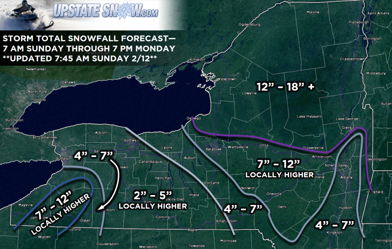
Good morning gang, just a quick post to give an updated snow totals forecast. I'm fairly confident now that areas including Ithaca, Penn Yan, Canandaigua, and even the greater Buffalo area are going to see the more in the way of rain or sleet than anything else during the daytime hours today. This will cut down dramatically on snow totals, but I did include a tag of "locally higher" just to cover for those areas that actually get more snow. We'll see some enhancement off of Erie, so I did put some higher totals in there.
Other than that, I'm confident that the Catskills and the Thruway corridor from Syracuse to Amsteredam will see anywhere from 7-12 inches of snow by tomorrow afternoon with, again, locally higher amounts depending on terrain and depending on how much sleet mixes in. (Speaking of sleet, that is my reasoning behind the 4-7 amounts for Auburn, Cortland, and eastern Broome County.)
North of the Thruway we're looking at all snow, at least a foot.
This is all subject to revision, with the biggest variable being how far north the warm nose makes it, combined with the timing of the transfer of energy to the coast. Once the coastal storm takes charge, it will flex its muscle, wrap in cold air at all layers of the atmosphere, and change everyone over to snow. Right now I think that will occur by sunset.
I'll throw out another update around suppertime tonight folks.